Getting there
The road to the waypoint
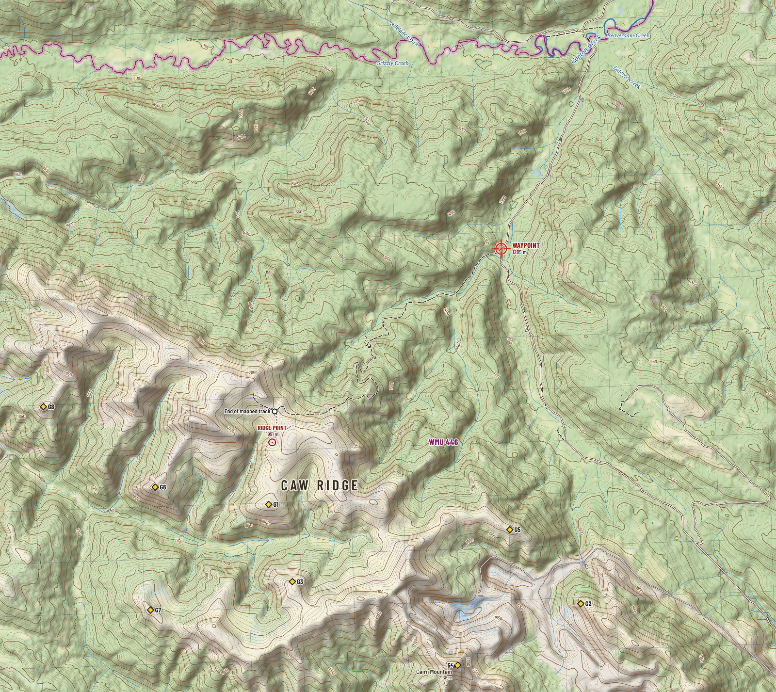
From Grande Cache it is 40 km to your waypoint: 9 km of pavement and 31 km of gravel through coal mine country. The waypoint is the Caw Ridge turnoff. From it an old exploration road climbs 717 m in 8.1 km to the alpine.
The drive
| Leg | Road | Surface | Distance | Running total | Notes |
|---|---|---|---|---|---|
| 1 | Through Grande Cache | Paved | 0.9 km | 0.9 km | From the middle of town out to Highway 40. Fuel here: there is none beyond. |
| 2 | Highway 40 north (Bighorn Highway) | Paved | 8.1 km | 9.0 km | Leave Grande Cache northbound. Cross the Smoky River. Watch for the Beaverdam Road sign on the left. |
| 3 | Beaverdam Road | Gravel | 31.4 km | 40.4 km | Crosses coal mine property and the main mine haul road. Stay on Beaverdam Road. Riders call it rough for a pickup and fine for small trailers, and speak of kilometre markers along it. |
| Waypoint | 40.4 km | The Caw Ridge turnoff, on the left. The road passes within 6 m of the point you gave. A staging area is reported here. |
The drive in profile
Height above sea level along the route from Grande Cache, metres. Low point 957 m, high point 1,531 m.
Show the numbers
| Distance | Height |
|---|---|
| 0.0 km | 1,257 m |
| 0.8 km | 1,255 m |
| 1.5 km | 1,213 m |
| 2.2 km | 1,162 m |
| 3.1 km | 1,095 m |
| 3.9 km | 1,035 m |
| 4.6 km | 974 m |
| 5.3 km | 960 m |
| 6.3 km | 961 m |
| 7.1 km | 983 m |
| 8.0 km | 972 m |
| 9.0 km | 974 m |
| 9.7 km | 1,019 m |
| 10.6 km | 1,087 m |
| 11.3 km | 1,159 m |
| 12.2 km | 1,250 m |
| 13.0 km | 1,301 m |
| 13.8 km | 1,374 m |
| 14.7 km | 1,450 m |
| 15.6 km | 1,522 m |
| 16.5 km | 1,489 m |
| 17.4 km | 1,449 m |
| 18.2 km | 1,416 m |
| 19.0 km | 1,374 m |
| 19.9 km | 1,290 m |
| 20.8 km | 1,204 m |
| 21.7 km | 1,152 m |
| 22.5 km | 1,129 m |
| 23.5 km | 1,117 m |
| 24.3 km | 1,116 m |
| 25.2 km | 1,116 m |
| 26.1 km | 1,088 m |
| 26.9 km | 1,121 m |
| 27.7 km | 1,145 m |
| 28.5 km | 1,199 m |
| 29.4 km | 1,243 m |
| 30.3 km | 1,274 m |
| 31.1 km | 1,315 m |
| 32.0 km | 1,381 m |
| 33.0 km | 1,433 m |
| 33.8 km | 1,428 m |
| 34.6 km | 1,418 m |
| 35.5 km | 1,393 m |
| 36.4 km | 1,379 m |
| 37.1 km | 1,353 m |
| 38.0 km | 1,380 m |
| 38.8 km | 1,348 m |
| 39.6 km | 1,318 m |
| 40.3 km | 1,285 m |
The route above was found by the program in OpenStreetMap, preferring better roads. It matches the directions published by the Municipal District of Greenview almost to the hundred metres: 8.1 km north on Highway 40, 30 km along Beaverdam Road to the Caw Ridge turnoff on the left, then 8.1 km up the old road to the top.

On from the waypoint to the ridge
The old road leaves the gravel at your waypoint and climbs 717 m in 8.1 km to the ridge top at about 2,002 m. It is an old mining exploration road, not maintained: eroded, with long cobble sections. Treat it as a route for an off-highway vehicle, a horse or your feet, not for a truck. From where the mapped track ends it is 0.6 km over open alpine to the ridge point.
| Leg | Way | Distance | Climb | On foot, up | On foot, down |
|---|---|---|---|---|---|
| Old road | Rough track | 8.1 km | 717 m | 2 h 15 min | 1 h 45 min |
| To the ridge point | Open alpine, no trail | 0.6 km | -10 m |
The climb in profile
Height above sea level along the old road from the waypoint, metres. It starts at 1,284 m and tops out at 2,002 m.
Show the numbers
| Distance | Height |
|---|---|
| 0.0 km | 1,284 m |
| 0.2 km | 1,294 m |
| 0.4 km | 1,306 m |
| 0.6 km | 1,316 m |
| 0.8 km | 1,324 m |
| 1.0 km | 1,343 m |
| 1.3 km | 1,350 m |
| 1.4 km | 1,364 m |
| 1.6 km | 1,387 m |
| 1.8 km | 1,405 m |
| 2.0 km | 1,424 m |
| 2.2 km | 1,448 m |
| 2.4 km | 1,460 m |
| 2.6 km | 1,487 m |
| 2.8 km | 1,502 m |
| 3.0 km | 1,504 m |
| 3.2 km | 1,518 m |
| 3.4 km | 1,531 m |
| 3.6 km | 1,548 m |
| 3.8 km | 1,565 m |
| 3.9 km | 1,574 m |
| 4.1 km | 1,597 m |
| 4.3 km | 1,610 m |
| 4.5 km | 1,642 m |
| 4.7 km | 1,644 m |
| 4.9 km | 1,673 m |
| 5.1 km | 1,715 m |
| 5.3 km | 1,732 m |
| 5.5 km | 1,730 m |
| 5.7 km | 1,741 m |
| 5.9 km | 1,768 m |
| 6.1 km | 1,795 m |
| 6.3 km | 1,818 m |
| 6.5 km | 1,839 m |
| 6.7 km | 1,861 m |
| 6.9 km | 1,894 m |
| 7.1 km | 1,914 m |
| 7.3 km | 1,933 m |
| 7.6 km | 1,962 m |
| 7.8 km | 1,979 m |
| 8.0 km | 1,994 m |
What riders report
None of what follows is official, and the newest of it is from 2023. It comes from public forum threads by people who have made the trip on quads and side-by-sides.
- Beaverdam Road is rough in a pickup and better suited to small trailers than large ones.
- The highway to the ridge top is just shy of 50 km.
- Staging areas are reported at the mine flats by the Smoky River off Highway 40, at Gustavs Flats, and at the Caw Ridge turnoff itself.
- Old exploration roads run along most of the ridge line once you are up. A loop is described that descends to the south past an open pit and meets Beaverdam Road about 8 km east of the turnoff.
- Sheep Creek Road, further north, is a better kept oilfield road but was reported gated to highway vehicles at kilometre 13, and signed against off-highway vehicles.
- Snow closed the top to riders in late May 2008 and again in June 2013. In autumn the same drifts arrive early.
- Fresh grizzly tracks are reported regularly along the access.
Radio controlled roads
Resource roads in this country carry loaded coal and log trucks. No radio channel is published for Beaverdam Road, and one forum post holds that radios are required of commercial traffic only. Drive with your lights on, keep right on blind corners, give trucks the road, and ask at the Grande Cache Tourism and Interpretive Centre (780-827-3300) about current conditions before you go.
The off-highway vehicle weapons rule
In WMUs 400 to 446 it is unlawful to carry a weapon on an off-highway vehicle from one hour before sunrise until noon during an open big game season. The exception is direct travel to an isolated campsite with the weapon and ammunition out of view in separate locked containers. If you ride the 8 km from the waypoint to hunt the morning, you ride without your rifle or you wait until noon. Many hunters camp high or walk.
Distances
| From | To Grande Cache | Road |
|---|---|---|
| Hinton (Highway 16) | about 140 km | Highway 40 north, paved |
| Grande Prairie | about 190 km | Highway 40 south, paved. About two hours. |
| Edmonton | about 430 km | Highway 16 west to Hinton, then Highway 40. About four and three quarter hours. |
| Grande Cache to the waypoint | 27 km | As the raven flies, bearing 330° true (NNW). |
Camping
Random camping is allowed on public land for up to 14 days in one place: keep 30 m back from water, and stay at least 1 km from a provincial park or recreation area. A Public Lands Camping Pass is required along the eastern slopes ($20 for three days or $30 for the year, per person); the official map appears to take in the land west of Highway 40 here, so buy one.
| Campground | Where | Notes | Coordinates |
|---|---|---|---|
| Sheep Creek provincial recreation area | Highway 40, 25 km north of Grande Cache | Closest developed site to the Beaverdam Road country. Boat launch. | 54.06217, -119.01122 |
| Smoky River South provincial recreation area | Highway 40 at the Smoky River bridge | 22 unserviced sites. Usually open to Thanksgiving. | 53.89036, -119.15852 |
| Sulphur Gates provincial recreation area | South-west of town, Willmore staging | 11 sites, open all year, road not kept in winter. Firearm discharge permit rules apply. | 53.85013, -119.18618 |
| Grande Cache municipal campground | In town | Check that it is still open this late in the year. | in town |
| Pierre Grey's Lakes provincial park | Highway 40, 37 km south | On the way in from Hinton. | 53.90438, -118.59179 |
Last services
Grande Cache has fuel (Fas Gas and Petro-Canada), a supermarket, hotels and motels, a hospital with a 24 hour emergency department, and an RCMP detachment. There is nothing past the Beaverdam Road turnoff: no fuel, no water you have not treated, no help you have not arranged. Fill the tank and the jerry cans in town.
Whose land
The ridge is provincial Crown land in the Green Area, within the Municipal District of Greenview and Treaty 8 territory. It is not a park. Two protected areas lie close: Willmore Wilderness Park about 8 km to the south-west, where hunting is allowed but no motor vehicle may go, and Kakwa Wildland Provincial Park about 12 km to the west.
The Aseniwuche Winewak Nation and the Mountain Métis have lived in this country for generations. The Nation's cooperatives and enterprises (Victor Lake, Susa Creek, Muskeg Seepee, Wanyandie Flats, Grande Cache Lake and Joachim) hold parcels along Highway 40. Treat them as private occupied land and ask before entering. Treaty and Métis harvesters may lawfully be hunting at times and under rules that differ from yours.
Change is coming
The Upper Smoky Sub-regional Plan, in force since November 2025, names Caw Ridge as part of a conservation area to be designated under the Provincial Parks Act. The plan says hunting will continue under existing law and that motorized recreation will be allowed in areas shown on a map the province will publish. As of the research for this guide the designation did not yet appear in the province's protected area data. Call 310-LAND (310-5263) for the present state of things.
