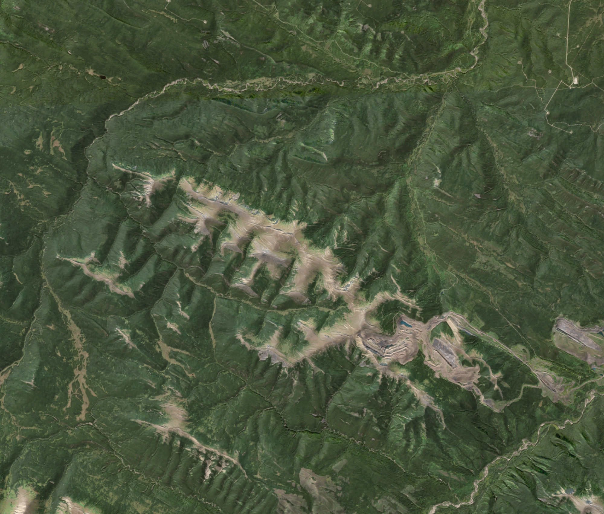
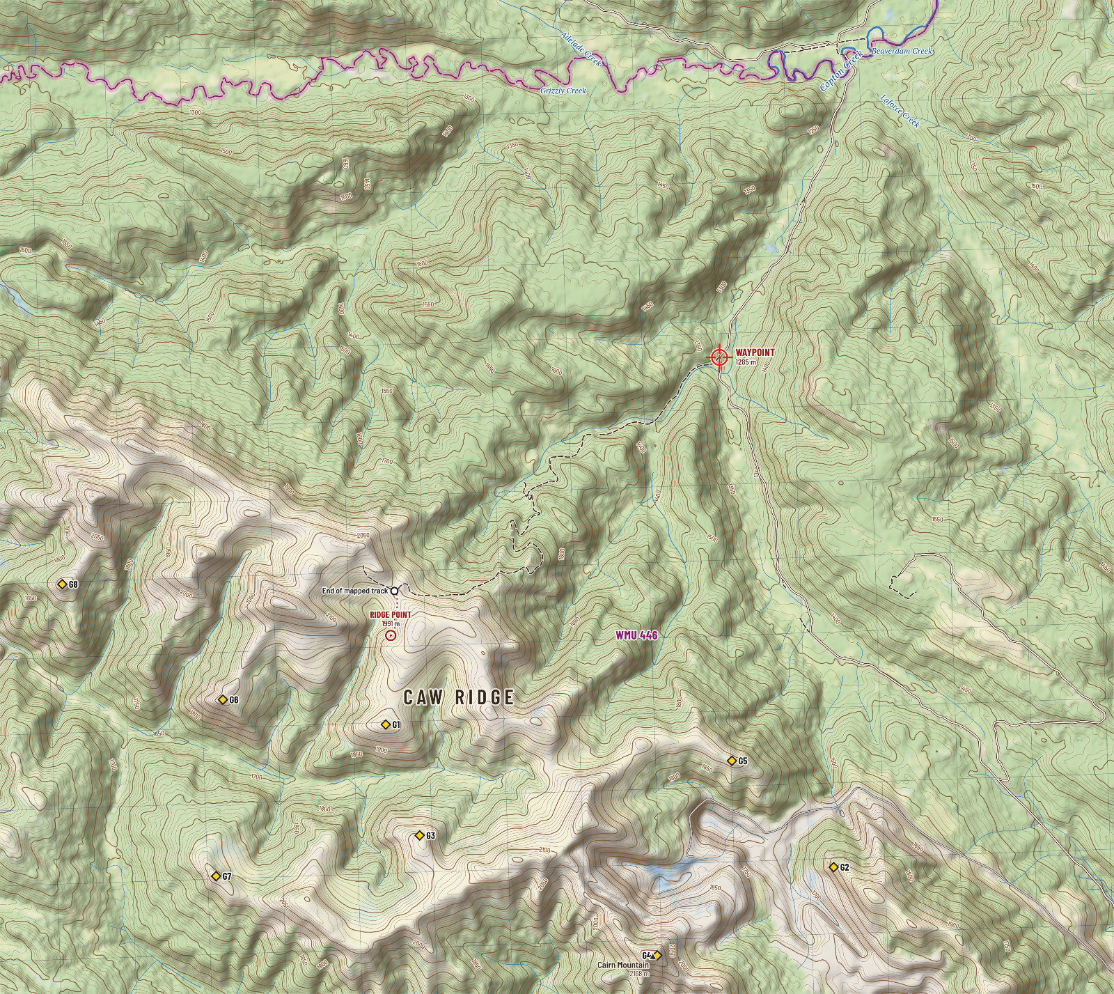
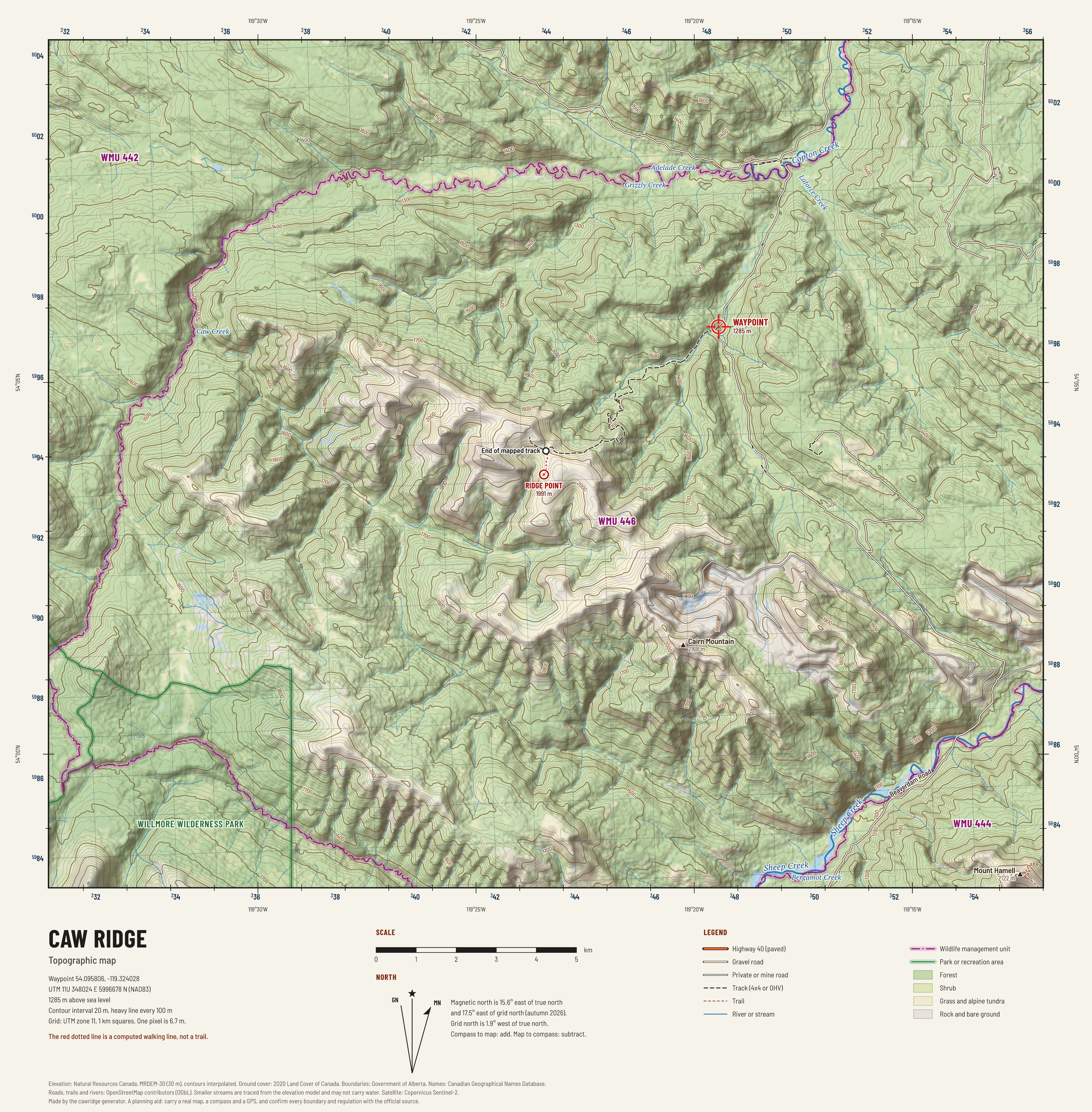
Caw Ridge is a high, open ridge in the foothills 26 km north-west of Grande Cache: alpine tundra and rock above a sea of spruce and pine, the home of the most studied mountain goat herd on earth, and the far end of a rough road. Your waypoint is the way in: the turnoff on Beaverdam Road at 1,285 m, where the old exploration road leaves the gravel and climbs to the ridge. This guide gathers what the public record knows about the ground between the two, draws it as maps, and sets out the rules and the risks.
- Elevation
- 1,285 m4,215 ft. In conifer forest. Forest runs up to about 1,880 m, and the ridge point is 707 m above you.
- Wildlife management unit
- WMU 446Kakwa River. Checked against the official boundary file.
- From Grande Cache
- 40 km by road9 km paved and 31 km gravel, to within 6 m of the waypoint. 27 km in a straight line.
- On to the ridge
- 8.1 km, 717 m upBy the old road, then 0.6 km over open ground to the ridge point. About 2 h 15 min on foot.
- Land
- Crown landNot in a park. Inside coal lease 1319020123. Treaty 8 territory.
- Legal light, 29 Sep
- 7:26 to 20:08Sunrise 7:56, sunset 19:38 MDT. Half an hour either side.
- Compass
- 15.6° eastMagnetic declination, autumn 2026. Grid north is 1.9° west of true.
- Coordinates
- 54.095806, -119.324028
11U 348024 E 5996678 N - Latest clear satellite pass
- 2026-09-18No snow on the ridge that day. See the image.
Read this first
- There is no mountain goat season here.WMU 446 has no goat season of any kind. The Caw Ridge goats are a research herd, followed animal by animal since 1989 and not hunted since 1969. Many carry ear tags or collars. Leave them be, and give them room.
- Caribou and grizzly bear are closed everywhere in Alberta.The waypoint is inside the Redrock-Prairie Creek caribou range and inside the core grizzly recovery zone. Be certain of your target: a caribou is not an elk, and a grizzly is not a black bear.
- Know what your tag allows.In 446, elk must be six point or better, moose in the rifle season is by draw, bighorn sheep is by draw only, and deer are on a general tag. The regulations page has the table.
- No weapon on a quad before noon.In WMUs 400 to 446 it is unlawful to carry a weapon on an off-highway vehicle from one hour before sunrise until noon during an open big game season. The 8 km from your waypoint up to the ridge is an off-highway vehicle trail. On foot it is about 2 h 15 min up and 1 h 45 min down.
- The road in crosses a working coal mine.Beaverdam Road runs through mine property. The municipal district's instruction is plain: stay on Beaverdam Road. Mine roads are private.
- Your waypoint is in the timber.94% of the ground within 3 km of it is forest. The open country is on the ridge above. The best glassing point found, G1, sees 6.8 km² of open country and is about 2 h 45 min on foot from the waypoint. The terrain page shows where to sit.
- Winter comes early.In recent winters the first snow reached the ridge point, at 1,991 m, between 23 Sep and 21 Oct, and the waypoint between 23 Sep and 9 Nov. The ridge forecast when this page was built: 2 cm of snow over the next four days, a low of -4°C and gusts to 66 km/h this week.
- Plan on no phone signal.Coverage is confirmed only in town. Carry a satellite messenger, leave a trip plan, and know that the nearest emergency room is in Grande Cache, 40 km back down the road from the waypoint.
The weather, low and high
At the waypoint, 1,285 m
Forecast as of 2026-09-29 23:06 UTC. With a connection this strip refreshes itself.
On the ridge, 1,991 m
Forecast as of 2026-09-29 23:06 UTC. With a connection this strip refreshes itself.
Highs and lows in °C, wind in km/h. The forecast model works on a coarse grid and scales its temperatures to 1298 m for the waypoint and 1957 m for the ridge point. Ridge top wind will run stronger than shown.
Ten autumns of weather, first snow dates, and sun and moon tables
The ground
In this guide
The ridge in 3D
Turn the ground in your hands. Drape any map over it, stand on any spot and look around, raise the glass, measure a shot, and tap anywhere to learn what is there.
Maps
34 sheets: topographic, satellite, height, slope, aspect, landforms, cover, wind shelter, sun, snow, walking time and what is in view. View, download, print.
Explore
Every sheet laid over the ground in one flat map, with your GPS position. Tap anywhere for height, slope, cover, landform, sun, snow and bearings. Works offline once saved.
Terrain
Where to glass from, the saddles animals cross, the summits, the benches and basins, how steep, which way it faces, where the wind strikes, and how long the walking takes.
Getting there
The drive from Grande Cache leg by leg, the climb to the ridge, staging, camping, fuel and distances.
Regulations
WMU 446 seasons for 2026, the rules particular to the mountains, licences, registration and who to call.
Wildlife
Goats, sheep, caribou, grizzly, elk, moose and deer: what lives here, what is protected, and when the rut runs.
Weather
Live forecast, the climate of ten autumns at ridge height, first snow by year, legal light for every day to the end of November.
Safety
Bears and meat care, emergency numbers, the hospital, communications, and a packing list that remembers your ticks.
Take it with you
There is no signal on the ridge. Save the guide to your phone before you leave town: every page, every map and the explorer will then open with no connection.
About 200 MB. Use wifi.